Wind & Waves
Sea Waves
The narrow strips where the land meets the sea, coastlines, are among the most dynamic environments on Earth. Relentless attack by waves gnaws away at even the hardest of rocky coasts, reshaping the shore with each passing wave. Even the most gentle waves change the shape of the shoreline each day in imperceptible ways.
A wave is a way in which energy travels from one place to another. There are many kinds of waves, such as water waves, sound waves, light waves, radio waves, microwaves and earthquake waves. All waves have some things in common.
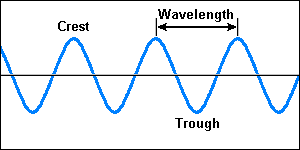
The highest point the waves reaches is called the crest. The lowest point is called the trough. The distance from one crest to the next is the wave length. The number of waves that pass a given point in one second is the wave's frequency.
It takes lots of energy to make the waves crashing against a shoreline. Where does this energy come from ? The single most important wave-building energy source is wind.
When wind reaches 2.5km/hr, gravity takes over from surface tension as the dominant force on wave form. The crests become more pointed and the troughs rounded. The wind reinforces the wave shape by pressing down on the windward side and eddying over the crest to reduce pressure on the leeward side. As the wind increases further to around 13km/hr, the crest of the waves steepen until they become unstable and break, producing white-caps.
When wind blows over the ocean's surface, it creates waves. Their size depends on how far, how fast and how long the wind blows. A brief, gently breeze forms patches of tiny ripples on the surface, where as strong, steady winds over long distances create large waves. But even when you feel no wind at all, you may encounter large swells created by distant storms.
Wind-generated waves may originate thousands of kilometers out at sea. Out in the deep open ocean, waves usually start out small and choppy. If the wind is strong and lasts long enough, the wave pattern becomes more organized. Storm-driven waves often travel towards the distant shore as low, rounded swells.
In the open sea, waves make floating boats bob up and down instead of pushing them along. This is because the waves travel through water, and do not take the water with them. As a wave arrives it lifts water particles. These travel forward, then down and back so that each particle completes a circle. Circling movements of particles near the surface set off smaller circling movements below them.

As mentioned earlier, waves only seem to carry water with them. In fact, each wave crest sets water particles circling. As swells approach the shallow coastline they begin to touch bottom. Water drags against the sea bottom, slowing its forward movement.
While the wave slows, water piles up, building higher and higher waves as the bottom shallows. Eventually the wave reaches a critical point when the steep advancing edge collapses. Breaking waves disintegrate into turbulent sheets of water that carry sand and gravel up onto the beach.
Beaufort Scale
The Beaufort Scale is still useful in providing a relationship between wind strength, state of sea and wave height. The scale allocates numbers to various ranges of wind speed and description of sea, and relates them to the behaviour of vessels under the influence of those winds.
The scale was devised by British Rear-Admiral, Sir Francis Beaufort in 1805, based on observations of the effects of the wind. Originally, the Wind Force Scale consisted of 13 degrees of wind strength, from calm to hurricane, and was based upon the effects of various wind strengths upon the amount of canvas carried by the fully rigged frigates of the period. In the days before elaborate meteorological instruments, Beaufort had chosen for his wind sensor the prime ship of the British fleet. The 1831 version of the wind scale as outlined in a memorandum to Commander Robert Fitzroy could be divided into three sections.
The first five states (Forces 0-4) described a ship's speed with all sails set and clean full, and in smooth water. The next five (Forces 5-9) concerned the ship's mission, the chase, and its sail-carrying ability. For example, in a fresh gale (Force 8), a well-conditioned man-of-war could just carry in chase, full and by, treble-reefed topsails, etc. The final three Forces (10-12) referred to a ship's ability to survive whole gale, storm, or hurricane.
In 1838, the British Admiralty officially prescribed the Scale and made its use mandatory for all ship's log entries, for, as it was defined, the Scale had no ambiguities for the sailors and officers of the day. But the winds of change move ever onward, and like Beaufort himself, the frigate eventually passed from the scene as the prime ship of the British Navy. Thus, when the Permanent Committee of the First Meteorological Congress met to adopt the Beaufort Wind Scale for international use in meteorological telegrams, changes were needed.
Since the frigate was no longer the dominant ship on the seas, a new "probe" was necessary to determine the wind's force. The original Beaufort force numbers were now subtly changed so that they referred to states of the sea or degrees of motion of trees instead of the sails on a frigate. But ambiguities soon arose, for the state of the sea also depends upon swell, fetch and water depth, and trees vary in their response to the wind.
Finally, in 1946, the International Meteorological Committee, while extending the scale to 17 values (the added five values further refining the hurricane-force winds), defined the scale values by ranges of the wind speed as measured at a height of 10 meters above the surface for each Force Number. In effect, this transformed the Beaufort Wind Force Scale into the Beaufort Wind Speed Scale.
The table below summarises the main features of the scale.
| Mean Winds | Wave Heights Open Sea |
Beaufort
Force | km/h | Knots | Description | Metres | International
Code |
| 1 | 2-6 | 1-3 | Light Air | 0.0 - 0.1 | Calm (Glassy) |
| 2 | 7-11 | 4-6 | Light Breeze | 0.1 - 0.3 | Calm (Rippled) |
| 3 | 12-19 | 7-10 | Gentle Breeze | 0.3 - 0.6 | Smooth (Wavelets) |
| 4 | 20-30 | 11-16 | Moderate Breeze | 0.6 - 1.2 | Slight |
| 5 | 31-39 | 17-21 | Fresh Breeze | 1.2 - 2.5 | Moderate |
| 6 | 40-49 | 22-27 | Strong Breeze | 2.5 - 4.0 | Rough |
| 7 | 50-61 | 28-33 | Near Gale | 4.0 - 6.0 | Very Rough |
| 8 | 62-74 | 34-40 | Gale | 6.0 - 9.0 | High |
| 9 | 75-88 | 41-47 | Strong Gale | 9.0 - 13.7 | Very High |
Swell
Swell is generally regular wave motion caused by large meteorological disturbances operating at a distance. Swell persists after the disturbance has disappeared and maintains a constant direction as long as it keeps in deep water. Swell can travel for considerable distances. Since swell may have been instigated by storm, the arrival of onshore swell can indicate that a storm is approaching.
Sea waves, caused by the local wind, are often superimposed on swell moving in from a distance. Interaction between the two can cause unpredictably high waves and danger for mariners.
 Fishing Tip : Fishing Tip : |
|
| Why not contact fishSA.com about your Fishing Tip |
|
|