Uluru
Mt. Uluru - Ayers Rock

Ayers Rock (Mount Uluru) is believed to have had its beginnings in the Precambrian era about 550 million years ago. Enormous mountain ranges were pushed up then eroded away over the next 200 million years, leaving the Mann, Musgrave and Petermann Ranges in Central Australia.
The sediments from these ranges was laid down on the Amadeus Basin, and further earth movements about 300 million years ago and an erosion process that continues even now at a very slow rate, began to create the spectacular features we see today.
  Consisting of Arkose, a course-grained sandstone rich in the mineral feldspar, Ayers Rock (Mount Uluru) achieves its famous red colour and flaky surface from the chemical decay of minerals and mechanical erosion. The characteristic rusty colour of the exposed surface of these flakes is just that � rust. It is caused by the oxidation or rusting of the iron in the arkose. The fresh arkose is a grey colour. Consisting of Arkose, a course-grained sandstone rich in the mineral feldspar, Ayers Rock (Mount Uluru) achieves its famous red colour and flaky surface from the chemical decay of minerals and mechanical erosion. The characteristic rusty colour of the exposed surface of these flakes is just that � rust. It is caused by the oxidation or rusting of the iron in the arkose. The fresh arkose is a grey colour.
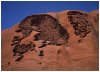
The sculptured shapes of the Rock are a combination of mechanical erosion and other events such as chemical changes caused by moisture. One of the geologic sites is a pattern known as "The Brain", sacred to the local Pitjantjatjara people. "The Brain" was one of the most prominent features exposed to the sunrise and definately warranted a snap.
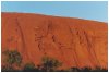
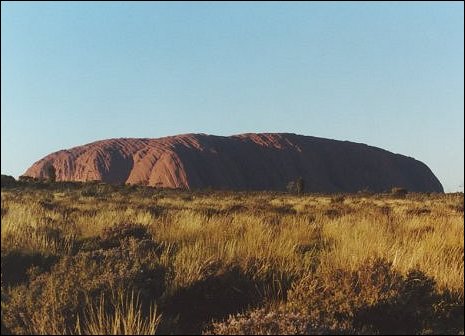
 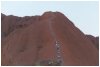 Ayers Rock (Mount Uluru), the world's largest monolith and an Aboriginal sacred site is Australia's most famous natural landmark. Visitors may wish to make the tough 1.6km ascent to the top or take a walking tour around the rock with an aboriginal guide , learning about its fascinating with the Uluru people and its importance in dreamtime legend. The photo on the left shows the steep incline that one must overcome to reach the top. The photo on the right show tourists attempting the ascent. Ayers Rock (Mount Uluru), the world's largest monolith and an Aboriginal sacred site is Australia's most famous natural landmark. Visitors may wish to make the tough 1.6km ascent to the top or take a walking tour around the rock with an aboriginal guide , learning about its fascinating with the Uluru people and its importance in dreamtime legend. The photo on the left shows the steep incline that one must overcome to reach the top. The photo on the right show tourists attempting the ascent.
Rising 862.5 metres above sea level (345 metres above the ground), Ayers Rock covers an area of 3.33 square kilometers. It has a circumference of 9.4 kilometres, a maximum width of 2.0 kilometres and a maximum length of 3.1 kilometres.
The first white person to reach and climb the Rock was William Christie Gosse in 1873. He named it after Sir Henry Ayers, then Chief Secretary and later Premier of South Australia. Aboriginal people are believed to have lived around Ayers Rock for several thousand years, and their name for Ayers Rock, "Uluru" is simply a place name without any special meaning.
This world heritage area is owned by the Anangu, the traditional landholders of the region. It is one of the most powerful parts of Aboriginal 'Tjukurrpa' (mythology), with many 'dreamings' centering on Uluru.
Changing colour throughout the day, Uluru at sunrise and sunset is astonishing. Below is a series of shots taken during sunrise, over a period of about 20 minutes.
 Photo 1 |
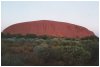 Photo 2 |
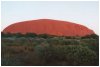 Photo 3 |
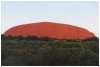 Photo 4 |
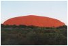 Photo 5 |
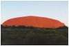 Photo 6 |
 Photo 7 |
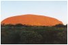 Photo 8 |
Admittedly, the photos above don't do it justice. To fully appreciate Ayers Rock (Mount Uluru), nothing equates to actually being there, an aspiration both Chinook and I intended to fulfill during our trip Up the Middle, Down Under.
 Fishing Tip : Fishing Tip : |
|
| Why not contact fishSA.com about your Fishing Tip |
|
| )
)
)
)
)
)
)
)
)
)
)
)