Closed Areas & Seasons
Aquatic Reserves / Closed Areas / Closed Seasons
Many fish have traditional breeding and nursery grounds. These are either spawning areas, to which fish migrate every year, or nursery areas where juvenile fish can develop and grow under optimum conditions and relative safety. When such areas are identified, closed areas may be implemented to protect the juvenile animals and their habitats.
Seasonal closures are declared to protect some heavily fished species during their breeding seasons. Female blue crabs, giant crabs, yabbies and rock lobsters with external eggs are protected because they are close to the completion of their breeding cycle. If caught, they must be returned to the water immediately.
Below is a list of some of the closures / closed areas :
Aquatic Reserves
The marine and estuarine waters of South Australia represent some of the most biologically diverse waters to be found along the temperate Australian coastline. This diversity is the result of a remarkable array of coastal landforms and habitats and the considerable variability in sea temperatures along the South Australian coast. These factors have combined to produce a rich variety of underwater organisms and communities, many of which are found no where else in the world.
The Government of South Australia is committed to the protection, wise use and enjoyment of South Australia's marine and estuarine habitats.
To this end, it has established a system of aquatic reserves along our coast to protect representative habitats, ecosystems and communities, while permitting appropriate uses and promoting public education.
South Australia's first Aquatic Reserve was established in 1971. Since then, a number of reserves have been established . In 1995, South Australia's first marine park was established in the Great Australian Bight.
In South Australia, there are 15 aquatic reserves or parks.
The links below will enable you to see (and print) enlarged maps and information about permitted activities in each of the State's Aquatic Reserves.
The coordinates shown on these maps are based on Australian Geographical Datum (AGD) 94 which coincides almost exactly with WGS84. Some adjustment may be required depending on the GPS navigational system used.
Rock lobster seasons
The rock lobster fishery is divided into two zones � Northern and Southern. The taking of rock lobster is prohibited during the following closures :
- Northern zone (W of Longitude 139o 0' 4.80"E (GDA 94) is closed between 6pm 31 May to 12 noon 1 November.
- Southern zone (SE of Longitude 139o 0' 4.80"E (GDA 94) is closed between 6pm 30 April to 6am 1 October.

Apart from these seasonal closures, berried rock lobster (females carrying eggs) is protected at all times and must be returned to the water immediately.
Rock lobster is totally protected at all times in rock lobster sanctuaries, which include :
Cape Jaffa
 Margaret Brock Reef
 Rivoli Bay
 Gleeson Landing

Abalone closure
The taking of abalone is prohibited in all of the waters of Waterloo Bay (Elliston) contained within the line commencing at the high water mark on the shore of Wellington Point across to Salmon Point.

Cuttlefish closure
The State Government has moved to further protect South Australia's unique cuttlefish spawning ground in False Bay, near Whyalla by implementing a year round closure.
As a result it is unlawful to take any cephalopods from the closed area. This includes cuttlefish, squid and octopus. The closure continues through until 31 December 2006.
The closed area includes all waters of the Spencer Gulf enclosed by a line from the lighthouse at Point Lowly to the southern end of the Point Bonython jetty, then in a south westerly direction to the eastern most point of the BHP jetty, (position latitude 33� 02' 12.63"s, longitude 137� 36' 1.98"e (GDA 94) near Whyalla, then to the high water mark at the base of the jetty, then following the high water mark along the shoreline in an easterly
direction back to the point of the commencement. This area still remains open to commercial and recreational fishers targeting other fish species.

Other Restrictions
All fishing is banned in the following areas :
- Within 150m of locks and weirs on the River Murray;
- At inlets to West Lakes and in front of private residences around the lake
- The portion of the waters of Gulf St Vincent off the coast of Wirrina Cove (Fleurieu Reef) bounded by a circle of radius 0.5 of a nautical mile centred on a point at latitude 35o 28' 48.90" s, longitude 138o 09' 34.85" e (GDA 94)
- In many aquatic reserves
Additionally, the following closed areas and seasons apply :
Blue Groper
In waters of Spencer Gulf, Gulf St Vincent, Investigator Strait and Backstairs Passage
north of the geodesic commencing at high water mark on the shore at Newland Head, position latitude 350 39' 00" south, and longitude 138o 31' 00" east, then in a direction of
238�T, to high water mark on the shore at Cape Willoughby in position latitude 35o 51' 10" south, and longitude
138o 07' 40" east, then from high water mark on the shore in position latitude 35o 53' 10" south and longitude 136o 32' 00" east, (west coast of Kangaroo Island adjacent to West Bay), in a direction of 321�T to high water mark on the shore at Cape Carnot, position latitude 34o 56' 45" south, and longitude 135o 37' 30" east at all times.
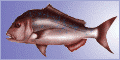
Snapper Closure
A total prohibition on the taking of snapper (Pagrus auratus) in all waters of South Australia exists from midday 1 November until midday 30 November 2006. Fishers taking snapper incidentally during these closure periods are required to returned them to the water immediately.
Bream
In the Onkaparinga River, upstream of the Main South Road bridge at Noarlunga from 1 September to 30 November (inclusive).
Goolwa cockles
From 1 June to 31 October (inclusive).
Razor fish
In upper Spencer Gulf in an area contained within a line commencing on the shore of Spencer Gulf adjacent to beacon No. 8, then due east to that beacon, then generally northerly to beacons 9, 13, 20, 19, 21, 23 and 28, then due west to Curlew Point. This area is closed during the months of January, February, October, November and December.
Molluscs
The taking of molluscs (shellfish) is prohibited in all waters of West Lakes.
Prawns
The taking of prawns is prohibited in all waters of South Australia in waters less than 10m deep and other waters subject to seasonal closures.
 Fishing Tip : Fishing Tip : |
|
| Why not contact fishSA.com about your Fishing Tip |
|
|